What is it?
It's located at 41 degrees North latitude, 73 degrees West longitude. It's 110 miles long. It averages 65 feet in depth. Its water masks a sandy, bedrock bottom. It's comprised of currents and tides that explain its variation in salinity. And it's home to plants, animals, and humans alike.
5
The question "What is it?" can be answered in many ways depending on your frame of reference. And an even better understanding of this body of water can be gained by understanding the cause and effect relationship these characteristics have on this body of water and the creatures that live in and around it.
5

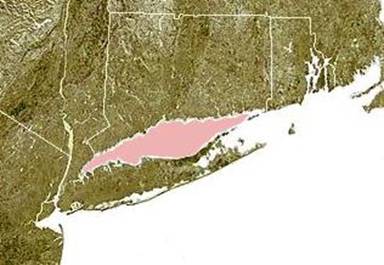
Figure 1. The Long Island Sound is shown highlighted in pink between Connecticut and Long Island. Based on public domain satellite photo courtesy of NOAA. © 2004 Matthew Trump.
Location
The Long Island Sound is in fact a "sound." This geographical term is used to describe a body of water found between an island and mainland. The Long Island Sound lies between Connecticut, to the north, and Long Island, New York to the south. On a globe, it is also important to recognize that the Sound is almost directly between the North Pole and the Equator. As a result, the temperatures can get as cold as -1°C in the winter and as hot as 22°C in the summer. This change in temperature from artic to tropical conditions gives the Sound four distinct seasons and changes both biotic and abiotic factors. Biotic factors are living or once living parts of an environment including plants, animals, bacteria, and fungi. Abiotic factors are non-living and include light, temperature, weather, soil, water, air, and minerals.
5
Water
Long Island Sound can also be described as an estuary because it is a partially enclosed coastal body of water, in which freshwater from rivers and stream meets and mixes with salt water from the ocean. This estuary has one major saltwater sources (the Atlantic Ocean) and four major freshwater sources (the Connecticut River, Thames River, Housatonic River, and Quinnipiac River) and many minor freshwater sources (streams). At 110 miles long the Sound receives salt water from both ends. On the eastern side the Race dumps about 25 billion gallons of salt water with each incoming tide. And on the western side the East River supplies more salt water. In addition to rivers and streams the Sound also gains freshwater in the form of precipitation from both rain and snow. Although most of the region surrounding the Sound receives an average of 30 to 40 inches of precipitation a year, the fresh water actually reaches the Sound via the rivers and streams. In this summer this process happens rapidly, but in the winter the freshwater remains on the land and does not enter the Sound until the snow melts. Therefore, the Sound has more freshwater in the early spring and less in the late summer. Another water factor that varies with season is salinity, or the salt content. The Long Island Sound averages a salt content of 28 parts per thousand (28 ppt), while ocean water contains around 35 ppt. It's also important to note that cold saltwater lies below warm freshwater giving the Sound an intricate circulation pattern. This fluctuation in salinity and temperature allows for greater biodiversity among organisms within the Sound. Organisms must have the ability to adapt to these changing estuary conditions.
5

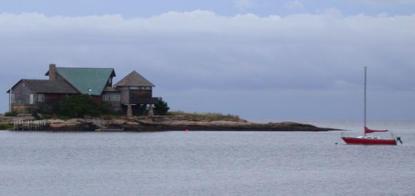
Figure 2. The Long Island Sound near Guilford, CT.
Aquatic Life
In addition, the Long Island Sound is a wonderful example of an aquatic ecosystem, or community of organisms living with one another and interacting with the physical environment around them. If one part of the environment is altered, such as oxygen levels or the addition or removal of a species, the entire ecosystem can be affected. And within this ecosystem, multiple habitats exist. Habitats, or areas in which organisms live, must provide the necessities to survival including: food, oxygen, water, space, and shelter. Some commonly found habitats in the Sound are intertidal zones (rocky intertidal zones, sandy beaches, tidal flats, salt marshes), water-land interfaces, and subtidal zones, which includes pelagic (open water) and benthic (bottom-dwelling). Each of these habitats has a unique landscape made up of various soils and rocks. Much of the landscape was shaped over 20,000 years ago by glacial movement. When the temperature rose, the glacier melted leaving sediments that formed a ridge down the middle of Long Island, New York. This left a freshwater lake until 19,000 to 15,000 years ago when the sea levels rose to the level of the Sound. Over time plants and animals took advantage of the Sounds varying habitats and made it a permanent home.
5
Intertidal Zone
The intertidal zone is located between the highest high tide and lowest low tide. Several habitats exist in this area including rocky intertidal, beaches, sand or mud flats, and salt marshes. Organisms living in any of these zones must be equipped to survive exposure to sun, wind and water submergence.
Rocky Intertidal
The rocky intertidal zone is dry between tides, but it also receives the powerful force of waves. Organisms living in this habitat must have adaptations that allow them to anchor to the rock bottom floor. For example, mussels use byssal threads and barnacles use cement to avoid being swept away. Seaweeds that live in this area also have a special chemical compound that allows them to hold more water to prevent dehydration from exposure to sun and wind.
Sandy Beaches
Sandy beaches also experience waves and dry conditions during low tide. In this area, organisms such as worms, clams, and mole crabs burrow into the sand to avoid the heat and dryness of the sun.
Tidal Flats
Tidal flats are usually made of sand or mud and they occur in places where grasses are unable to grow due to waves. Without vegetation, sediments move easily providing even less safety from the sun and wind. Animals living in this area, like worms and clams, burrow into the sand or mud. During high tide many organisms move to tidal flats to find food.
Salt Marshes
Salt marshes are broken into two areas, high and low. High marshes can tolerate occasional flooding of salt water and plants such as cordgrass exist here. The low marsh experiences flooding twice a day and is home to tall cordgrass and organisms such as fiddler crabs and fish, which swim away with the tide. Salt marshes allow provide nutrients, feeding grounds, spawning areas, and temporary homes for many other organisms. Shellfish, crabs, snails, worms, and small land mammals utilize marshes. Many species of migratory birds stop to rest and feed in the marshes. Marshes also prevent flooding, as an acre of salt marsh can hold 30,000 gallons of water. The grasses also help filter the water and trap sediments and contaminants.
This area is also most in need of our help. An estimated 50-65% of Connecticut's salt marshes have disappeared due to human development, especially dredging, filling, and overharvesting. Much of what is left of the marshes experiences pollution. Fishermen worry that this loss of marsh habitat is threatening the sustainability of Connecticut's fisheries. The Tidal Wetlands Act of 1969 and the Coastal Management Act of 1979 seek to conserve these areas.
14,15
Water-Land Interface
Although the water-land interface does not experience daily tidal changes it is affected by spring tides, which occur twice each month, along with salt spray and heavy flooding. These factors restrict the organisms that can live in these sometimes-salty environments.
9
Subtidal Zone
The subtidal zone is always submerged water and because this habitat offers constant conditions a variety of organisms can survive here. This area is divided into two parts: benthic zone and pelagic zone. The benthic zone is where benthos, or bottom dwellers live including flatfish and crabs. The pelagic zone is where jellyfish and many roundfish, such as bluefish live because they thrive in the water column.