Wind wave size formation
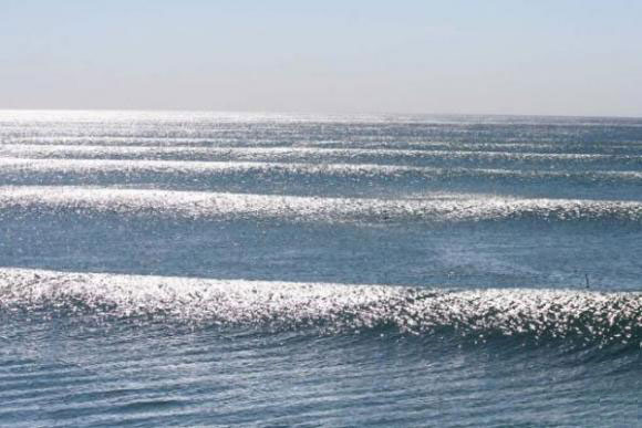
The majority of large breakers on an ocean beach result from distant winds far from that shoreline. Three factors influence the
size formation
of
wind waves
:
-
1. The speed at which the wind travels.
-
2. The
fetch
or distance of open water over which the wind has blown.
-
3. The time during which the wind has blown over a given area.
These three factors work together to determine the size and shape of ocean waves: the greater each of the variables, the larger the waves. Waves are characterized by:
-
1. Wave Height (from trough to crest).
-
2. Wavelength (from crest to crest).
-
3. Wave Period (arrival time intervals of consecutive crests at a stationary point).
-
4. Wave propagation direction (with respect to north).
Waves present multiple heights in the same oceanographic area however, for weather reporting and for scientific analysis of wind wave statistics, their characteristic height over a period of time is usually expressed as
significant wave height
. This figure represents the average height of the highest one-third of the waves in a given time period (usually chosen somewhere in the range from 20 minutes to twelve hours), or within a specific wave or storm system. Consequently, the largest individual waves are likely to be about twice the reported significant wave height for a particular day or storm, due to the variability of wave height.
Wind wave type formation
Three unique
type formations
of
wind waves
develop over time:
-
1. Ripples, or capillary waves.
-
2. Seas.
-
3. Swells.
Ripples appear on smooth water when the wind blows, but will subside as the wind ceases. The restoring force that allows them to propagate is surface tension. Seas are the larger-scale, often irregular motions that form under sustained winds. They tend to last much longer, even after the wind has died, and the restoring force that allows them to persist is gravity. As seas propagate away from their area of origin, they naturally separate according to their direction and wavelength. The regular wave motions formed in this way are known as swells.
Some waves undergo a phenomenon called “breaking.” A breaking wave is one whose base can no longer support its top, causing it to collapse. A wave will break when it surges into shallow water, or when two wave systems oppose and combine forces. When the slope, or steepness ratio, of a wave is too great, breaking is inevitable. A 1:24 slope may be a long, shallow swell found in deep waters. A 1:14
and higher slope is a wave that is too steep to remain coherent and maintain its integrity. Waves will also break if the wind forces escalate sufficiently to blow the wave crest off the base of the wave.
Spilling type of surf
Three main types of breaking waves are identified by surfers or surf lifesavers. Their varying characteristics make them more or less suitable for surfing, and each breaking wave type presents different dangers.
-
1.
Spilling
, or
rolling
: these are the safest on which to surf; they can be found in relatively sheltered areas.
-
2.
Plunging
, or
dumping
: these break suddenly and can “dump” swimmerspushing them to the bottom with great force. Strong winds can cause dumpers; they can also be found where there is a sudden rise in the sea floor.
-
3.
Surging
: these may never actually break as they approach the water’s edge, as the water below them is very deep. These waves can knock swimmers over and drag them back into deeper water.
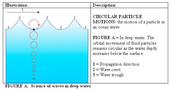
Since ocean surface waves are mechanical waves that propagate along the interface between water and air and the restoring force is provided by gravity, they are often referred to as surface gravity waves. As the wind blows, pressure and friction forces perturb the equilibrium of the ocean surface. These forces transfer energy from the air to the water, forming waves. In the case of monochromatic linear plane waves in deep water, particles near the surface move in circular paths, making ocean surface waves a combination of longitudinal (back and forth) and transverse (up and down) wave motions. As the wave amplitude or height increases, these particle paths no longer form closed orbits: after the passage of each crest particles are displaced a little forward or backward from their previous positions, a phenomenon known as Stokes drift.

While the ocean depth increases and in deep water as illustrated above [FIGURE A], the radius of the circular motion decreases in length, reducing the orbit. Whereas when a depth equal to half the wavelength Λ is reached, the orbital movement decays to nearly zero. The celerity or phase speed of the surface wave is well approximated by

where:
-
c = phase speed;
-
Λ
= wavelength;
-
d
= water depth;
-
g
= acceleration due to gravity at the Earth’s surface.
In deep water, where

and the hyperbolic tangent approaches 1;
c
is computed in m/s and approximates 1.25
 , when Λ is measured in meters. This expression demonstrates that waves of different wavelengths travel at different speeds.
Wave velocity also increases with wave depth and the relative difference in density. For an ocean depth of 4000m, a wave’s celerity or speed would be about SQR (10 x 4000) = 200 m/s = 720 km/hr, and similar to the cruising speeds of jet aircraft.
The general formula required for these calculations is
c =


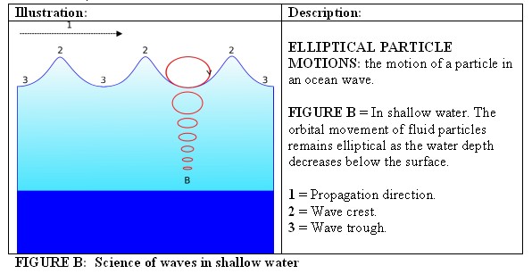
When waves propagate in shallow water as illustrated above [FIGURE B], where the depth is less than half the wavelength, the particle trajectories are compressed into ellipses and elliptical orbits, subject to Boussinesq equations or shallow water equations. As the water depth
d
decreases towards the coast and in shallow water, the velocity of the crest and the trough of the wave will also be transformed: the crest moves faster than the trough, causing surf and a breaking of the waves.
Shallow water equation models have only one vertical level, so they cannot directly encompass any factor that varies with height. Vertical pressure gradients are nearly hydrostatic, and horizontal pressure gradients are due to the displacement of the pressure surface, implying that the velocity field is nearly constant throughout the depth of ocean water.

FIGURE C: Wave Groups
Wave velocity also has implications during a storm, where the fastest waves are the ones with the longest wavelength. Consequently, the first storm waves to arrive on the coast are the long wavelength swells. When several wave trains are present, as is typical across the surface of the ocean, the waves form groups. In deep water the groups travel at a group velocity, which is half of the phase speed.
Each wave within a group appears to begin at the back of group, increase in size and eventually disappear at the front of the group as illustrated above [FIGURE C].
The movement of ocean waves can be captured by wave energy devices that track wave groups. The energy density per unit area of regular sinusoidal waves depends on the water density Ρ, gravity acceleration
g
and the wave height
H
, which is equal to twice the amplitude,
a
:

The velocity of propagation of this energy is the group velocity. A wave group of larger amplitude moves at half the average speed of its component waves; and the wave’s energy spectrum does not move at the speed of the waves but at the group velocity.
When distant storms send long waves out over great distances, they arrive at a time that corresponds with the group velocity, not the wave velocity. Therefore, a group of waves with a period of 14 s would travel at a group velocity of 11 m/s, not 22 m/s, and take approximately 24 hours, not 12 hours, to travel to a shore at 1,000 km distance. The important practical application of this wave science is solving the 3D wave equations back through time. These methods allow tracking the signal source from the measurements, performed in several places that are frequently quite far from the point where the wave has originated. Most ocean-based wave systems are comprised of many more than two components, each having generally different wave amplitudes and wave periods. This does not alter the group-based behaviors and velocities however; the interference between wave trains of different periods, moving in the same direction forms an irregularity of waves.
Disproportionately large coastal waves are referred to as
Sneaker Waves
, a term used to describe what can often appear in a wave train without warning. Sneaker waves are formed when the energy of a number of smaller waves becomes
focused
, and that several smaller waves have run into each other and created constructive interference. Constructive interference means that the individual wave peaks coincided and created a new wave that is the sum of those waves that were superimposed. Because of their larger size than preceding waves, sneaker waves can catch unsuspecting swimmers, washing them out to sea. While sneaker waves are a universal coastal phenomenon, a higher incidence of sneaker waves has been traced to several states in the United States: Northern California, Oregon and Washington. While these ideas have no scientific basis, one common belief that has wide circulation and has entered popular culture through music and literature predicts that out of a certain number of waves, one will be much larger than the others: every seventh wave is the popular predictable pattern.
While tides that are caused by the moon and sun’s gravitational forces, tsunamis that are caused by underwater earthquakes or landslides, and waves generated by underwater explosions or the fall of meteorites have a quantitative origin, other individual waves that travel outside of groups do not. These waves are distinctly different as they traverse across the ocean independently as “freak waves,” “killer waves,” “king waves,” “monster waves,” or “rogue waves” and can attain the extreme height of approximately 30 meters. In oceanography, they are more precisely defined as waves whose height is more than twice the significant wave height (SWH), which is itself defined as the mean of the largest third of waves in a wave record. These huge deep ocean waves are believed to form in a similar process to the way Sneaker Waves are thought to form, only on a much more massive scale.
Ocean wave measurement
Seafaring observations of waves have been recorded for over 130 years. This long record of the wave climate is complemented by indirect measurements of wave activity found in the Earth recorded by seismometers. More accurate quantitative measurements can be made using a wave pole on a fixed structure. An observer stands on the shore in a designated spot and sights the wave alongside a pole positioned between them and the waves. Such poles are often part of weather monitoring stations located along coastlines, particularly those associated with lighthouses. Electronic poles known as wave staffs are often used for precise engineering applications, and are operated on some research platforms such as the Aqua Alta tower in the Adriatic Sea, offshore of Venice. Wave staffs are usually replaced by radar (widely used in the Netherlands) or laser altimeters (such as found on some U.S. NDBC stations) for routine measurements.
A more common and robust way of measuring waves uses a buoy that records the motion of the water surface, which does not require a fixed platform. The buoy-recorded motions provide a time history of the water elevation for that location and statistics can be calculated including the significant and maximum wave heights and periods. Modern wave rider buoys usually measure their movement along the three dimensions and so also give information about wave direction. For the south east Queensland coastline there are wave rider buoys about every 100 km along the coast. The wave rider buoys are typically positioned off the entrances of major ports or major recreational surfing or swimming beaches. A network of wave rider buoys properly positioned can allow the interpolation of the wave climate for that region. Wave rider buoy data is a typical input for coastal modeling, the wave rider wave train is typically the deep water wave climate that is then refracted across the seabed contours into the wave breaking zone. In coastal areas, the wave-induced velocities and pressure fluctuations can also be recorded using pressure gauges and current meters, similar to measuring tides.
Wave heights can also be measured from space, at least in a statistical sense, using the change in the form of radar pulses reflected off the sea surface by altimeter radars as found on the French/U.S. Topex/Poseidon and Jason satellites. Other radar techniques, either ground-based wave radar or airborne systems such as real or synthetic aperture radars, can also provide measurements of wave statistics. These radar systems are best suited for long period waves or swells, allowing the tracking of swells over very long distances.
Ocean wave models
Surfers are very interested in a predictable wave climate. Predictions of the surf quality for upcoming days and weeks are available from many websites that also provide weather forecasting. The Ocean Wave models are driven by more general climate models that predict the winds and pressures over the oceans.
Ocean wave models are also an important part of examining the impact of shore protection and beach management. For many coastal areas more information about the wave climate would improve contemporary environmental understandings, therefore estimating the effect of ocean waves is important for managing littoral environments.